Since time immemorial, Traditional Owners have interwoven their culture and spirituality with the Great Barrier Reef (the Reef).
The Marine Park Authority and Traditional Owners are working together to integrate modern marine park management and traditional knowledge to protect this irreplaceable iconic World Heritage Area.
A major partnership over the past decade has been through the Indigenous Land and Sea Country Partnerships Program, a $20 million investment in Traditional Owner management of the Reef.
The program provided resourcing to support the development and implementation of Traditional Use of Marine Resources Agreements (TUMRAs).
Traditional Use of Marine Resources Agreements are community-based plans for management of traditional resources which are accredited in legislation and have proved a successful mechanism for joint management of the Reef.
Traditional Use of Marine Resources Agreements describe how Great Barrier Reef Traditional Owner groups work in partnership with the Australian and Queensland governments to manage traditional use activities on their Sea Country.
Each Traditional Use of Marine Resources Agreements has a committee to manage the agreement and traditional use of marine resources in their Sea Country, including traditional take, if any of important species such as dugongs and turtles. Their management of traditional use is based on both cultural lore and contemporary science and are also used for broader Sea Country planning and management.
In the past 10 years, the area of Sea Country covered by Traditional Use of Marine Resources Agreements has successfully doubled with the joint partnerships building a level of trust and knowledge previously unprecedented on the Reef.
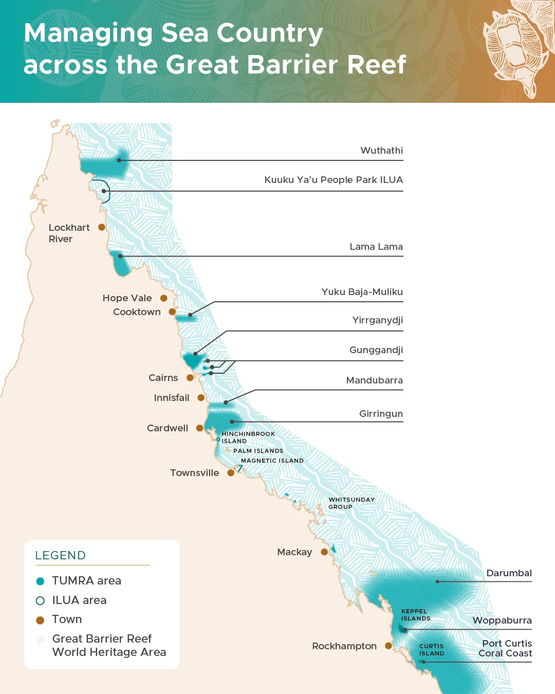
The number of Traditional Use of Marine Resources Agreements has increased from four to 10 — plus an Indigenous Land Use Agreement — covering 18 Traditional Owner groups.
Today, more than 43 per cent of the Marine Park coastline is managed under a these agreements.
Significantly, the program has strengthened partnerships between Traditional Owners and government, with some using their Traditional Use of Marine Resources Agreement to encourage external partnerships and investment.
The program is a major contributor to the outcomes of the Aboriginal and Torres Strait Islander Heritage Strategy for the Great Barrier Reef Marine Park, which sets out how the Authority will work with Traditional Owners to keep Indigenous heritage strong, safe and healthy.
We look forward to the next decade and beyond of increasing co-management, as we deepen our relationships with Traditional Owners to keep Sea Country strong, safe and healthy.
Traditional Use of Marine Resources Agreements
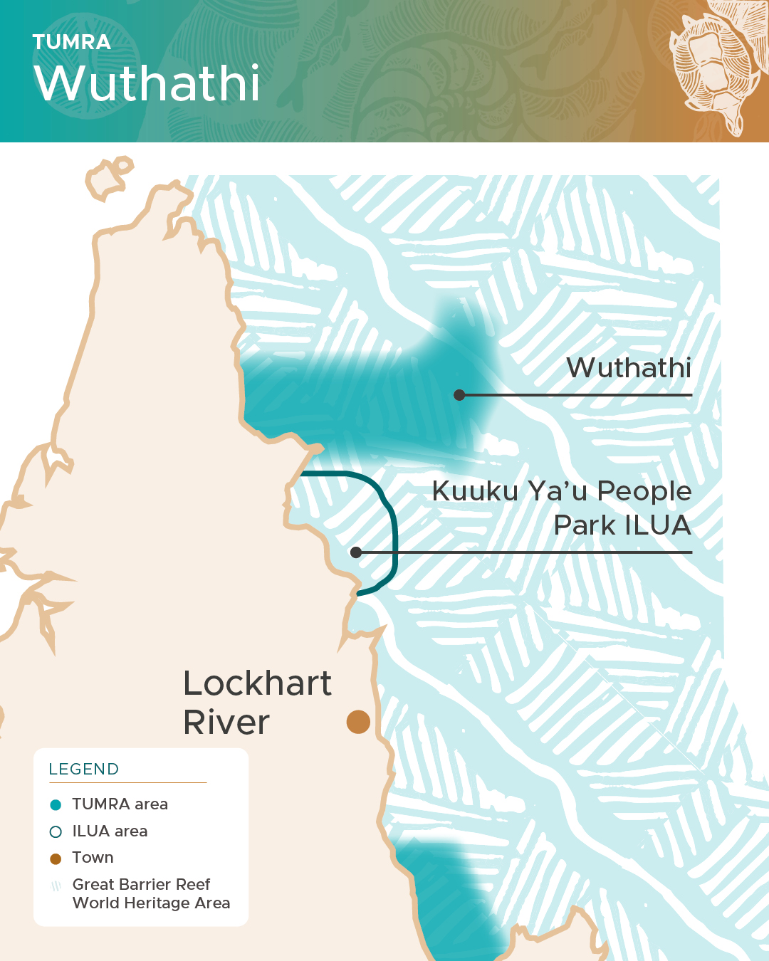
Wuthathi (Wuth-ath-ee) are the Traditional Owners for the Shelburne Bay area of Cape York Peninsula and their Traditional Use of Marine Resources Agreement, first accredited in June 2008, covers their traditional Sea Country area out to the eastern edge of the Great Barrier Reef Marine Park.
Wuthathi Karakara (Sea Country) includes Shelburne Bay out to Thukuruu (Raine Island), the outer Great Barrier Reef and the Coral Sea. Wuthathi Karakara has many islands: Muulinchum (Clerke), Thingkamu (Gore) and Uunthayma (Hicks) and also Nii’inthal (Cockburn Reef), I’inthal and Rukuya (Sir Charles Hardy group) and the Saunders group. Overall, our Wuthathi Karakara (Sea Country) connections extend across some 1,182 km2 of Australia’s mainland, coastal and offshore islands, and 8,072 km2 of marine waters within the Great Barrier Reef World Heritage Area and the Coral Sea.”1
Wuthathi Traditional Owners have a clear vision for managing their sea country and their agreement forms an integral part of this as they work toward developing a new agreement for the future.
-
Wuthathi Aboriginal Corporation RNTBC and Wuthathi Traditional Owners 2022. Mintha Kuntha Wuthathi Ngaachi Indigenous Protected Area Management Plan 2023-2033. Wuthathi Aboriginal Corporation RNTBC, Cairns.
For more information visit Wuthathi Aboriginal Corporation website.
Full name of the Legal Entity: Wuthathi Aboriginal Corporation RNTBC
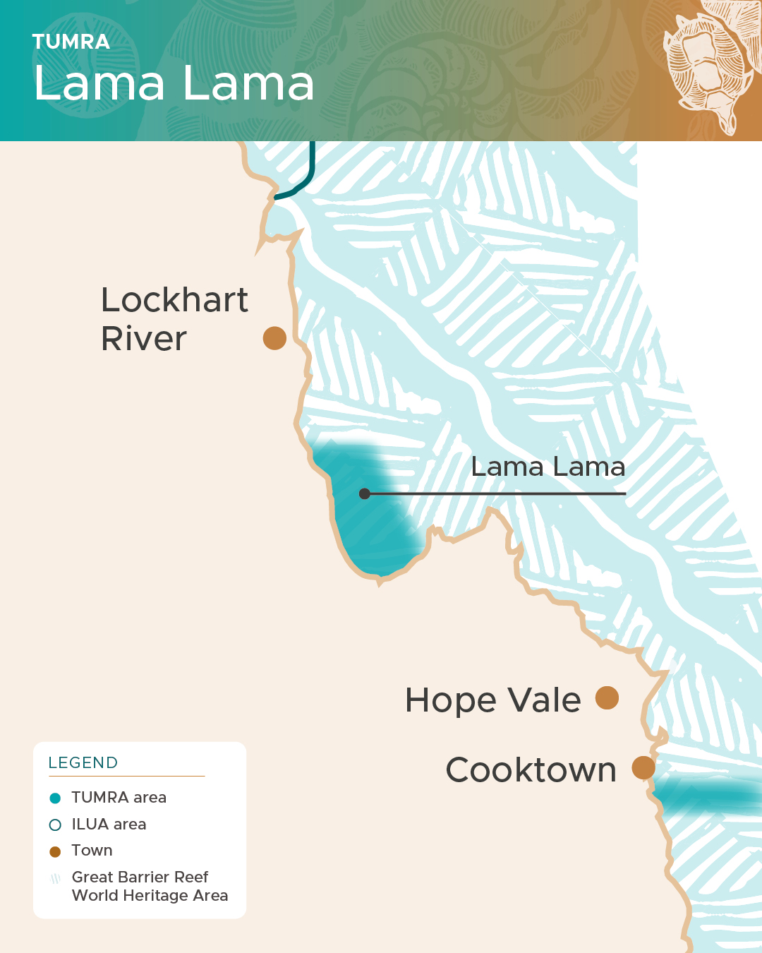
The Lama Lama (Lumma Lumma) Traditional Use of Marine Resources Agreement covers Sea Country that extends through Princess Charlotte Bay to the Normanby River in the south.
First accredited in August 2013, the agreement supports compliance activities, research and education, and a junior ranger’s program. The agreement will result in opportunities to learn new skills and offer employment and economic development for people in the region.
Through the Yintjingga (Yint-jinga) Aboriginal Corporation, the Lama Lama Traditional Owners already coordinate a Ranger Program and jointly manage the Lama Lama National Park and Marrpa Islands National Park with the Queensland Government. The Lama Lama Traditional Owners have developed an agreement that will meet their aspirations for managing Sea Country.
For more information visit Yintjingga Aboriginal Corporation Facebook page.

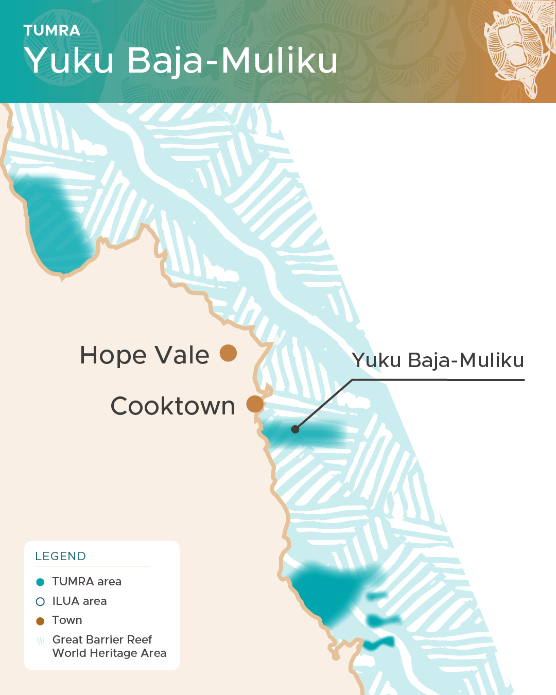
Yuku-Baja-Muliku (Yu-ku Ba-jah Mul-i-ku) are the Traditional Owners of the Archer Point area, south of Cooktown. Their sea country borders the Wet Tropics rainforests, and extends out to the eastern edge of the Great Barrier Reef
The Yuku-Baja-Muliku Regional Traditional Use of Marine Resources Agreement was first accredited in August 2013 and covers 1088 km2 stretching from Monkhouse Point south to Forsberg Point and extending east to just past the Ribbon Reefs. It’s an environmentally significant region rich in biodiversity. The agreement stipulates that turtle and dugong cannot be hunted outside of the Traditional Owners’ permit management system.
Yuku-Baja-Muliku Traditional Owners operate a turtle rescue and rehabilitation centre at Archer Point and run a comprehensive ranger program that undertakes a wide range of land and sea management initiatives. Rangers identify and monitor seagrass beds, develop visitor infrastructure, and manage pests, weeds, and fire. Yuku-Baja-Muliku also carry out cultural heritage management of story places, sacred sites, rock shelters and fish traps.
For more information on Yuku-Baja-Muliku, visit their website at: https://www.archerpoint.com.au/
Full name of the Legal Entity: Yuku Baja Muliku Landowner and Reserves Limited

Yirrganydji (Yirri-gand-jee) Traditional Owners are the saltwater people of the Yirrgay dialect, spoken along the coast from Cairns to Port Douglas in North Queensland. The Yirrganydji Traditional Use of Marine Resources Agreement was accredited in April 2014. It covers an area of sea country between Cairns and Port Douglas that extends far offshore to include outer reefs and islands “to where the sun rises on the horizon”.
The Yirrganydji Traditional Use of Marine Resources Agreement provides the ability to isolate illegal activities that are occurring in the marine park from the care, traditional use, and harvest of marine resources by the Yirrganydji people, the Traditional Owners of that area. Yirrganydi are actively involved in Ranger programs, species monitoring, communication, and education programs.
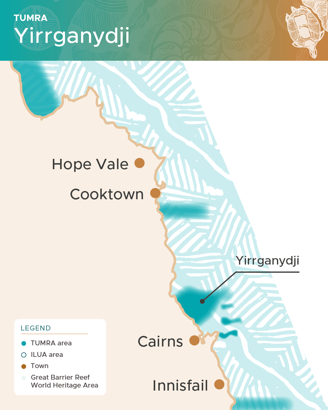
For more information on Yirrganydji, visit their website at https://dawulwuru.com.au/lmanagement/yirrganydji-tumra/
Full name of the Legal Entity: Dawul Wuru Aboriginal Corporation

Gunggandji (Gun-gand-jee) traditional land and Sea Country estate includes the coastal land and waters immediately to the east of Cairns. The Gunggandji Traditional Use of Marine Resources Agreement (TUMRA) covers three key areas: Green Island, Michaelmas Cay, Fitzroy Island, and the surrounding waters. Michaelmas Cay and the adjoining reef is a shared resource for Gunggandji and Yirrganydji peoples, which is managed under joint partnerships.
The Australian and State governments accredited the first Gunggandji Traditional Use of Marine Resources Agreement on 28 June 2016.
Under the Gunggandji Traditional Use of Marine Resources Agreement, no hunting of turtle or dugong is allowed in these areas. Through its dedicated Indigenous Compliance program, the Great Barrier Reef Marine Park Authority provides compliance assistance to Gunggandji Traditional Owners to implement the agreement.
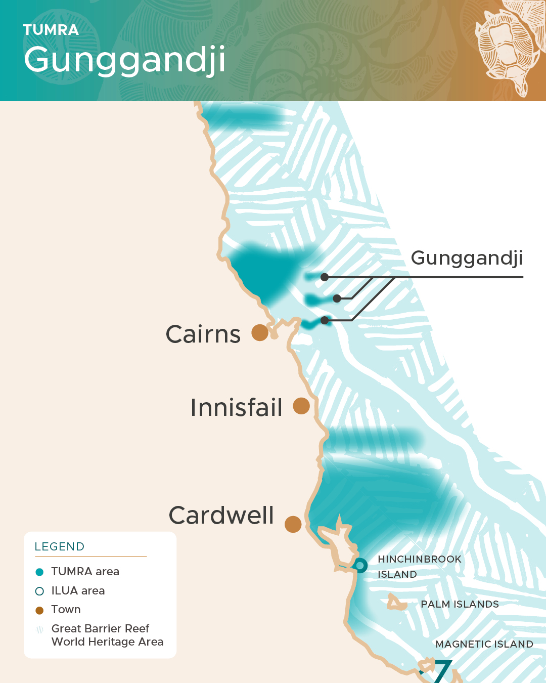
Full name of the Legal Entity: Gunggandji Aboriginal Corporation RNTBC
Mandubarra Sea Country extends from Mourilyan Harbour, south to the mouth of Maria Creek at Kurrimine Beach, the north and south Barnard Islands group and coastal and outer reefs including King Reefs and Sisters-Stephens Reef and extends to the eastern edge of the Great Barrier Reef. Mandubarra’s Traditional Use of Marine Resources Agreement (TUMRA) was accredited in April 2018 for a duration of 10 years. They hope to grow Traditional Owner involvement in the management of the Great Barrier Reef.
Mandubarra Traditional Owners are committed to caring for Country and to pass on knowledge and culture. With a proud heritage and breathtaking scenery, Mandubarra people have a unique patch with a complex range of challenges. For example, being adjacent to urbanised areas of the GBR, Mandubarra Traditional Owners have commercial and tourism-based interests operating in Sea Country.
In recognising this challenge, the Traditional Owners have implemented a moratorium on traditional hunting of turtles and dugong, developed a Junior Ranger program as well as a turtle nesting monitoring program whereby the Mandubarra Traditional Owners and the community collaboratively work to care for Sea Country.
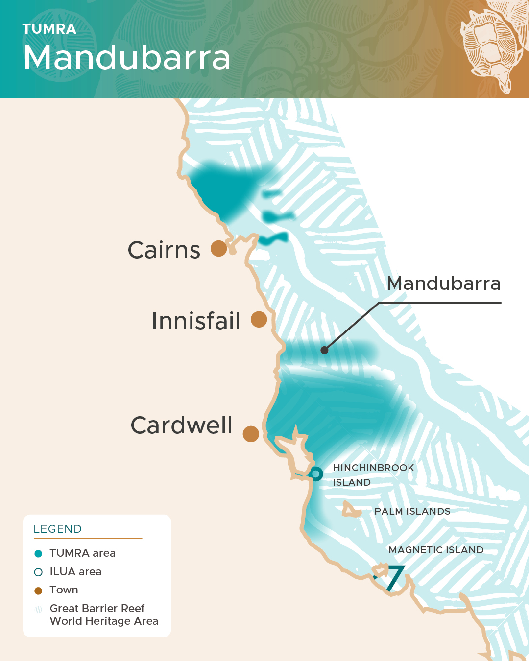
For more information on Mandubarra, visit their website at http://www.mandubarra.com.au/
Full name of the Legal Entity: Mandubarra Aboriginal Land and Sea Incorporated
The Girringun (Girrin-gun) region saltwater Traditional Owners were the first Traditional Owners in the Great Barrier Reef Marine Park to develop an accredited Traditional Use of Marine Resources Agreement. The six Girringun Aboriginal Corporation’s Sea Country groups endorsed the agreement: Djiru (Jh-roo), Gulngay (Gull-nay), Girramay (Girra-may), Bandjin (Band-jin), Warrgamay (Worra-ga-may) and Nywaigi (New-ay-ghee).
The Girringun Aboriginal Corporation, for and on behalf of its saltwater groups, has now developed its fourth agreement, which the Australian and Queensland governments accredited in November 2019. This agreement builds upon their first (2005), second (2008) and third (2010) agreements. It applies to Sea Country between Rollingstone in the south and north to Mission Beach and extends east of Hinchinbrook Island to the outer Great Barrier Reef.
Under their TUMRA, Girringun has become involved in the research efforts to gather data on the habitat areas, including the locations, extent and monitoring of seagrass beds, sea grass species, and the numbers and general locations of turtles and dugongs, particularly within the Dugong Protection Area (DPA) around Hinchinbrook and Goold Islands.
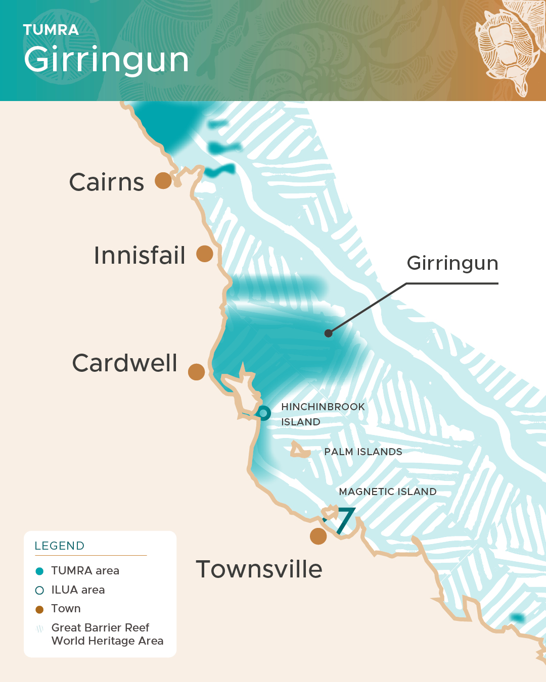
For more information on Girringun, visit their website at https://www.girringun.com/tumra
Full name of the Legal Entity: Girringun Aboriginal Corporation
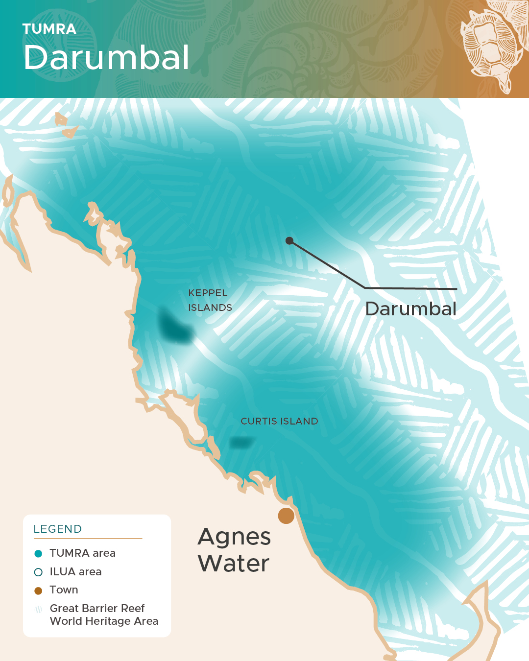
Darumbal (Da-rum-bul) people are the Traditional Owners of the Rockhampton / Shoalwater Bay area, and their Sea Country extends eastward to the Swains Reefs on the eastern edge of the Great Barrier Reef. The Darumbal Traditional Use of Marine Resources Agreement (TUMRA) was accredited in December 2021, and covers an area of approximately 36,606 km2 of the Great Barrier Reef Marine Park. It was the first such agreement to be accredited for a 15-year duration and is currently the largest agreement of its kind.
The northern boundary extends from Broad Sound to the Raglan Creek in the south, adjoining the Port Curtis Coral Coast Regional Traditional Use of Marine Resources Agreement and includes all lands and islands up to the Highest Astronomical Tide (HAT), important tourism sites and several Marine National Parks, a Preservation Park zone and Conversation Park zones. The TUMRA excludes the Woppaburra TUMRA area which sits within the boundaries.
The TUMRA is proving to be a platform for establishing career pathways into vocational and professional fields, business ventures such as contracting opportunities, partnership agreements including, Ranger Programs, collaborative research, and monitoring of Sea Country, to name just a few such activities.
For more information on Darumbal, visit their website at https://darumbal.com.au/
Full name of the legal entity: Darumbal Enterprises Pty Ltd

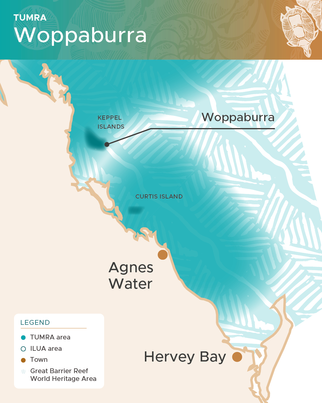
The Woppaburra (Woppa-burra) people are part of the wider Darumbal language group, and the Traditional Custodians of the Keppel Islands and surrounding Sea Country, located offshore from Yeppoon in central Queensland. Their clan totem is Mugga Mugga (Mugga-mugga) – the Humpback Whale – which is often seen in their Sea Country during their ceremonial time which coincides with its annual migrations.
The Woppaburra agreement first took effect in June 2007 and is known as the Woppaburra TUMRA. The Woppaburra TUMRA area currently covers 561 km2 and was the first offshore agreement of its kind. Additionally, the third and most recent Woppaburra agreement was the first such agreement that was entered into for 10 years.
Under the agreement the Woppaburra people continue to develop and implement important Sea Country management initiatives in partnership with marine management agencies such as QPWS as well as the Konomie (Kon-oh-mee) Island Environmental Education Centre, which is the only offshore environmental education centre run by the Queensland Education Department. TUMRA implementation includes working with scientists and researchers, managing traditional hunting protocols, the monitoring of plants and animals, and compliance training
Visit the Woppaburra website or Woppaburra TUMRA Aboriginal Corporation official Facebook page.
Full name of the legal entity: Woppaburra TUMRA Aboriginal Corporation

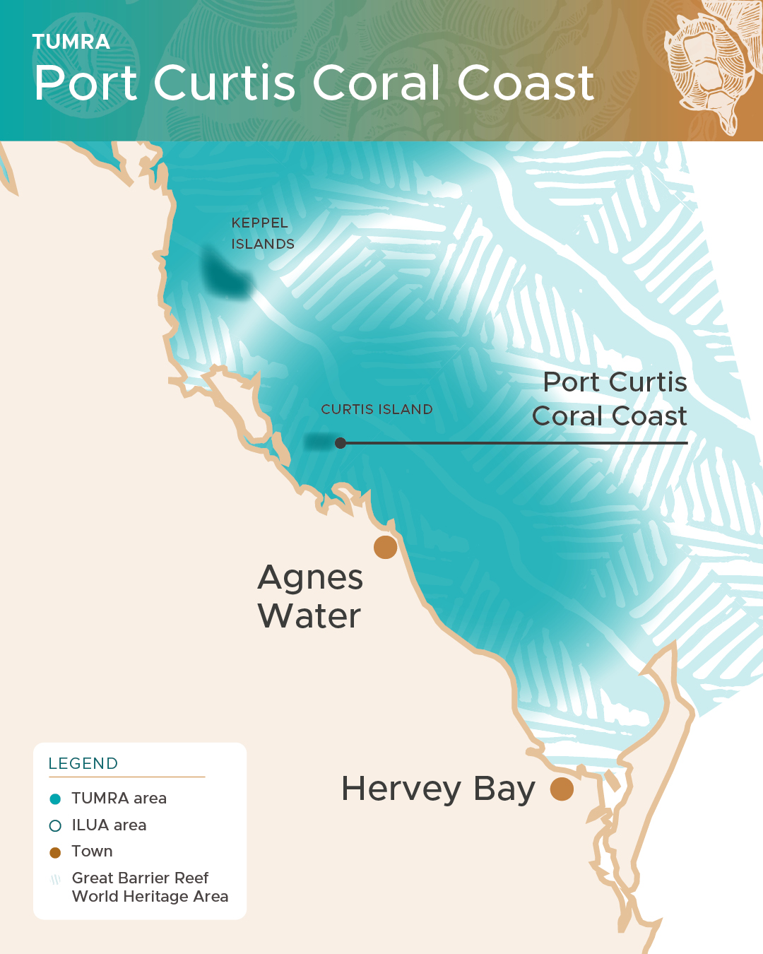
First accredited in August 2011, the Port Curtis Coral Coast Regional Traditional Use of Marine Resources Agreement was again accredited in April 2019 and will run for 10 years. It covers an area almost 10 times the size of the Australian Capital Territory or 26,386 km2. The agreement area extends from Burrum Heads, south of Bundaberg, north to and including the waters around Curtis Island off Gladstone.
Under the agreement, Port Curtis Coral Coast Traditional Owner groups, which include Byellee (By-ee-lee), Gooreng Gooreng (Gor-ang gor-ang), Gurang (Gurr-ang), and Taribelang Bunda (Tarra b’lang bunda), are committed to initiating management strategies that will positively impact their Sea Country.
The Gidarjil (Gid-ar-jil) Development Corporation supports the TUMRA Steering Committee on behalf of the four Traditional Owner groups as well as supports Land and Sea Rangers, both male and female, and supports Junior Rangers in schools throughout their region. These all serve to deliver TUMRA management outcomes on their land and Sea Country.
For more information on Port Curtis Coral Coast, visit their website at https://www.pccctrust.com.au/legals/cultural-heritage-tumra/
Full name of the Legal Entity: Gidarjil Development Corporation Limited

Indigenous Land Use Agreements are agreements about the use and management of land and waters that are made between one or more native title groups and other people or parties.
The Australian Government through the Great Barrier Reef Marine Park Authority is a party to the Kuuku Ya'u People's Indigenous Land Use Agreement, with implementation managed in the same way as a Traditional Use of Marine Resources Agreement.
The Kuuku Ya'u agreement off Cape York Peninsula is the first such agreement in the Marine Park and runs from Olive River in the north and south to just beyond Lockhart River.
It recognises Traditional Owner native title rights and interests in the management of nearly 2000 square kilometres of sea country out to the Great Barrier Reef.